


Collaborating Institutions
Schmidt Ocean Institute’s longest expedition of the year was tremendously ambitious, spending close to 477 hours on a mapping survey of the world’s single largest underwater volcano. The science team, led by Dr. William Sager of the University of Houston, was able to gather nearly 73 million bathymetric soundings and approximately 1.7 million measurements of the volcano’s magnetic field. The cruise survey was very successful, accomplishing 98% of the planned mapping track and covering an area of nearly one million square kilometers.
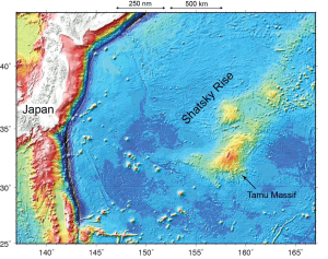
The Magnetic Anomolies cruise was focused on Tamu Massif, located about 1,600 km east of Japan. The process that created this undersea volcanic mountain, with an area equivalent to the U.S. state of New Mexico, remains a mystery. The goal of this research was to better understand how Tamu Massif was formed, by collecting magnetic data with a magnetometer. One of the few oceanic plateau volcanoes formed during a time of geomagnetic reversals, Tamu Massif holds a unique record of undersea geographic formation: magnetic anomalies in the oceanic crust. This makes it easier to understand the underwater volcano’s history and the key interactions it has with the mid-ocean ridges.
One thing that stands out about this survey is its sheer size. It was an ambitious cruise to cover all of Tamu Massif, the world’s largest known single volcano.
— Will Sager

By gathering the magnetic data, scientists are able to “read” the magnetic anomalies preserved within the plateau during its eruption. These stripes indicate laterally-constrained volcanism similar to mid-ocean spreading ridges, but this interpretation is not consistent with previous theories of Tamu Massif as an effusive volcano with far-traveled lava flows. Indeed, from older data it appears that the northeast end of the volcano has stripes, but the southwest part does not. The magnetic anomalies map created during this cruise will take some time to analyze, but a wide positive anomaly oriented SW-NE along the axis of Tamu Massif can clearly be seen. This is flanked by deep low magnetic anomalies on the north and south side. What this indicates is that Tamu Massif has zones of stronger and weaker magnetization. “Previous work on the Tamu Massif magnetic anomaly has been frustrated by the poor quality of older geophysical survey data. With careful attention to magnetic data collection and navigation, the new Falkor data will make it possible to make the best-ever magnetic anomaly and bathymetry maps of this gargantuan volcano” said Chief Scientist Will Sager.
previous work on the Tamu Massif magnetic anomaly has been frustrated by the poor quality of older geophysical survey data. With careful attention to magnetic data collection and navigation, the new Falkor data will make it possible to make the best-ever magnetic anomaly and bathymetry maps of this gargantuan volcano.
— Will Sager
In addition to mapping magnetic anomalies, dozens of secondary cones atop the big volcano, probably formed late in the volcano’s history, were also imaged. In places like Hawaii, many volcanoes form along rift zones, but here, the cones were scattered all over, implying Tamu Massif does not have well-defined rift zones. There were also many canyons cut into the sedimentary cover by the downslope sediment flows, which will be identified and traced using the new data. The maps also show basal escarpments (cliffs) on the west side of Tamu Massif. The science team now has more questions, wondering if these faults could be formed by different parts of the volcano sinking at different rates, or if they are the results of landslides?
Dr. Sager has referred to Tamu Massif as having a “Jekyll and Hyde” personality because of the differences in styles of eruption (constrained or effusive) implied by the magnetic anomaly data. The massive volcano developed at a triple junction of spreading ridges, which left behind recordings of magnetic anomalies that are the key to figuring out how it erupted. The science team expects that the large amount of new data collected during this expedition will help unlock the answers.
